The shrinking Colorado

The Colorado River flows through the Grand Canyon at sunrise as seen from the south rim in Grand Canyon National Park in Arizona on Tuesday, Oct. 11, 2022.
Written and photographed in 2022 for Deseret News
With additional reporting by Kyle Dunphey.
One hundred years since the signing of the Colorado River Compact, the West’s most critical river system is in crisis. When the agreement’s signatories divvied up the Colorado, they may have been unaware they were basing their math on falsely optimistic estimates of its flow. They were, however, keenly aware they were allocating nothing for Native American tribes, Mexico nor the natural flow of the river itself.
While the overarching Law of the River has evolved, the basis of it is still rooted in this document, and its repercussions continue to ripple along every bend of the river.
Today, the Colorado and its tributaries provide water for 40 million people and support billions of dollars in agriculture and recreation for seven U.S. states, 30 Native American tribes and parts of Mexico. While demand continues to increase, drought and climate change have decimated the mountain snowfall that feeds the river.
The Bureau of Reclamation and other agencies that manage the river’s water are scrambling to come up with operational changes that can reduce demands on the river, and have told the 7 states that make up the Colorado River Basin they must save 2-to-4 million acre-feet of water.
Change has traditionally come slowly in the realm of western water policy. Despite the growing urgency from policymakers and the public, only time will tell whether enough change can be made before the river runs dry.

The headwater of the Colorado River, in the green meadow at left, is separated by a dirt road from the Grand Ditch in Colorado on Thursday, July 14, 2022. The Grand Ditch is a 14-mile diversion that siphons water that otherwise would have flowed into the Colorado River out of the Never Summer Mountains, allowing the water to flow over the continental divide to eastern Colorado.


Columbine flowers grow and a deer checks out a two-legged visitor near the headwater of the Colorado River in Rocky Mountain National Park.
In a verdant valley at 10,000 feet elevation in Colorado’s Rocky Mountains, the Colorado River starts its 1,450 mile journey toward the sea. On a July morning, dewdrops sparkle on blades of grass as the sun rises over the surrounding mountains. The mighty river is just a trickle in this idyllic meadow, slowly percolating to its lowest point. If you take a narrow view, all is pristine and untouched. But if you zoom out, the West’s most crucial waterway has been already been altered even before its water has a chance to form a minor stream.
The Grand Ditch, dug largely by hand from 1890 to 1936, siphons water from 11 tributary streams in the Never Summer Mountains that would normally flow into the Colorado and instead dumps the water over the Continental Divide to serve the thirsty eastern plains of the state the river is named for. The water in the ditch flows swiftly and silently to the northeast, separated from the headwater of the Colorado by an earthen berm, never to meet.
This is just the first of hundreds of diversions and dams that make the Colorado River one of the most plumbed waterways on the planet. Its most well-known — Hoover Dam and Glen Canyon Dam — are cogs in a complicated machine that delivers water to 40 million people and a multibillion-dollar agricultural industry in the southwestern U.S. and Mexico.
But up here in Rocky Mountain National Park, a young deer with velvet antlers plods along beside purple and white columbine flowers and couldn’t be more indifferent to the river’s grand destiny.


Kelby Iverson turns off an irrigation valve after flooding an orchard overnight on his property in Hurricane on Friday, Sept. 9, 2022. Iverson farms alfalfa and raises beef cattle and relies on water diverted from the Virgin River, a tributary of the Colorado.
Kelby Iverson, right, his wife, Kathie, and three of their six children, Westynn, 17, Makadie, 10, and Daelyn, 15, pray before eating breakfast together at their home in Hurricane on Friday, Sept. 9, 2022.
Agriculture uses 85% of the water in the Colorado River basin. No matter how efficient cities become, the river’s math will not balance out without agriculture playing a role in conservation. Kelby Iverson’s family first started irrigating land in southwest Utah more than 100 years ago, which means he enjoys some of the most senior water rights.
Under the Law of the River, which is not one document but the amalgam of all the river’s regulations, those who started putting water to use earliest in time get the first right to the water, in perpetuity - a concept known as prior appropriation.
To Iverson, feeding families is amongst the most beneficial uses for the region’s water. His family raises a relatively small herd of cattle and grows alfalfa to feed them. They also graze on federal land, but due to the ongoing drought there’s not much wild forage out there for the cattle this year, and he’s been forced to cut his herd in half.
Iverson said he’s all for growing more efficient, but those savings don’t do anything to protect the bottom line of his business, because there is no mechanism to pay users for the water they save.
“If I save 50% of my water, but I don’t have any farm ground to put it on ... I just got a 50% haircut because I was more efficient. And I don’t get any more compensation because I took that cut for the water I own.” he said. “Where does it go?”
That might change soon, though. At the meeting of the Colorado River Water Users Association meeting in Las Vegas in December, upper basin states including Utah gave the green light to a pilot program to pay users $150, or more, for every acre-foot of water they conserve. The money for this program will come out of money earmarked in the Inflation Reduction Act.

Glen Canyon Dam holds back the waters of Lake Powell in Page, Ariz., on Monday, July 18, 2022.
The 710-foot-tall Glen Canyon Dam, completed in 1963, retains the second-largest human-made reservoir in the country behind to Lake Mead. Besides its role as a hydroelectric power plant and the robust recreation economy built around the reservoir, Lake Powell serves as a water savings account for the four states that make up the Upper Colorado Basin.
As inflows have decreased due to drought and climate change, the water level in Lake Powell has declined more than 170 feet from its high point, now holding less than 23% of its capacity.
Recent models from the Bureau of Reclamation show several scenarios in which both Lake Powell and Lake Mead could fall below “power pool,” which is the minimum water level that would allow water to flow through the hydroelectric power plants. If that should happen at Lake Powell, Glen Canyon Dam would have to rely on its river outlet works, which were not designed to deliver the 7.5 million acre-feet of water that the Upper Basin is obligated to deliver downstream under the Colorado River Compact.
In August, Reclamation announced they would begin studying whether physical modifications can be made to the dam to allow water to continue to be released if water levels should drop below the designed minimum levels.

The Colorado River cuts its path through southern Utah near Moab on Friday, July 22, 2022.
After 20 years of drought, the water scarcity problem in Colorado River Basin is compounding. While the region’s mountains are receiving less of the snowfall that feeds spring runoffs, parched soil and higher temperatures mean that an even smaller percentage of the spring snowmelt makes it into streams, rivers and reservoirs.
To describe what they are seeing happen in the basin, some scientists have begun to move away from calling it a drought in favor of another term - aridification. While even the most pronounced and pervasive droughts eventually end, aridification is indefinite.

Eric Balken, executive director of Glen Canyon Institute, walks barefoot through Clear Creek Canyon, a side canyon off the Escalante River arm of Lake Powell while on a media tour on Thursday, Oct. 6, 2022. This portion of the canyon only recently emerged above the receding waters of the reservoir.


A primrose blooms and a frog swims in the waters of Davis Gulch, a side canyon on the Escalante River arm of the reservoir, on Thursday, Oct. 6, 2022. This area of the canyon was once deep under the waters of Lake Powell but has since reemerged as the reservoir's water level has declined.

The steep canyon walls of Davis Gulch, a side canyon on the Escalante River arm of the reservoir, are reflected in a pool of water on Thursday, Oct. 6, 2022. This area of the canyon was once deep under the waters of Lake Powell but has since reemerged as the reservoir's water level has declined.

Eric Balken, executive director of Glen Canyon Institute, takes in Cathedral in the Desert, an amphitheater inside Clear Creek Canyon off the Escalante River portion of Lake Powell, while on a media tour on Thursday, Oct. 6, 2022. The formation was, for many years, deep under the waters of Lake Powell but has reemerged as the reservoir's water levels have declined.
“Look at all these primroses popping up!” hollers Eric Balken, executive director of Glen Canyon Institute. We are a couple of miles up Davis Gulch, a side canyon off the Escalante River. Or, more accurately, we are a couple of miles from where we could park our powerboat, as this canyon is one of approximately 125 that were flooded when the waters of Lake Powell began to rise behind Glen Canyon Dam.
Balken points out the Goodding’s willows, the different grasses, the cottonwood seedlings taking root. A frog kicks through shallow water to evade the human visitors.
“This is miraculous. This is amazing,” Balken says. “The scale of change happening here is so hard to wrap your head around.”
Balken has been bringing guests into these canyons for 14 years. Each time he goes the landscape is changed. Even on trips separated by only six months, the reservoir’s edge may be a mile or more farther down canyon — that’s how fast Powell’s waters are declining at times.
In the part of a canyon still flooded by Lake Powell, the world is silent and still. The vertical canyon walls hit glassy, dark water and are reflected back toward the sky. Maybe a fish jumps. A crow calls. But mostly it is a hard intersection of rock and water.
As that water recedes and the canyon floor breathes air, it begins to revert back to something closer to its natural state. Mud flats are incised by the flowing creek. Grasses begin to sprout. Insects return, filling the air with a gentle and unceasing hum. Fremont cottonwoods sprout and grow, reaching up toward the canyon rim.
“Ultimately when you get to areas that have been out of the water for 20 years, you see full-on forests,” Balken said. “To me that’s the most hopeful thing, when you see the 30-, 40-, 50-foot willow and cottonwood trees that are like little forests in there. To me those look, sound and smell like healthy desert riparian ecosystems.”
Balken calls Glen Canyon the heart of the Colorado River. He points out that it’s bounded by Canyonlands National Park, Grand Canyon National Park, Grand Staircase-Escalante National Monument and Bears Ears National Monument.
“All of the most prized, protect land of the Colorado plateau, Glen Canyon is the heart of all of that.”

Christine Rock brings fresh hay to feed her sheep and goats on her family’s property in the Douglas Mesa area of the Navajo Nation in Utah on Thursday, Nov. 17, 2022.


Herman Chee, Jr. digs deep into a feed bin while helping tend to Christine Rock's sheep and goats in the Douglas Mesa area of the Navajo Nation in Utah on Thursday, Nov. 17, 2022.
Christine Rock sheds a tear as she talks about the importance of raising livestock and caring for the land, a tradition passed down from her mother and ancestors before her, while bringing fresh hay to feed her sheep and goats on her family's property in the Douglas Mesa area of the Navajo Nation in Utah on Thursday, Nov. 17, 2022.
The 30 Native American tribes in the river basin were not allocated any water when the Colorado River Compact was signed in 1922. The compact mentions them in only a single sentence, saying that the compact’s terms have no bearing on the United States’ treaty obligations to the tribes.
Through a series of lawsuits and settlements, the tribes have now largely been recognized as holding significant and senior water rights, but for many that is simply “paper water.” Without infrastructure to deliver water to the people, it doesn’t count for much.
While the Bureau of Reclamation spent lavishly over decades to develop water projects in the West, the Bureau of Indian Affairs was chronically underfunded.
Today on the Navajo Nation, an area roughly the size of West Virginia, 1 in 3 residents lack access to clean drinking water at their homes.
Navajo Nation resident Christine Rock has running water at her home in the nearby community of Oljato-Monument Valley, but must haul water from her home or community wells to fill an underground cistern at her mother’s home on Douglas Mesa, and for the livestock they keep there. For her family, keeping livestock is not a luxury but a necessity and a tradition passed down for all time. It also gives Rock comfort that her people will weather the coming storm, as water becomes increasingly scarce in the region.
“One day, you’re going to be hungry,” Rock’s mother tells her, “and you’ll eat what you take care of.”
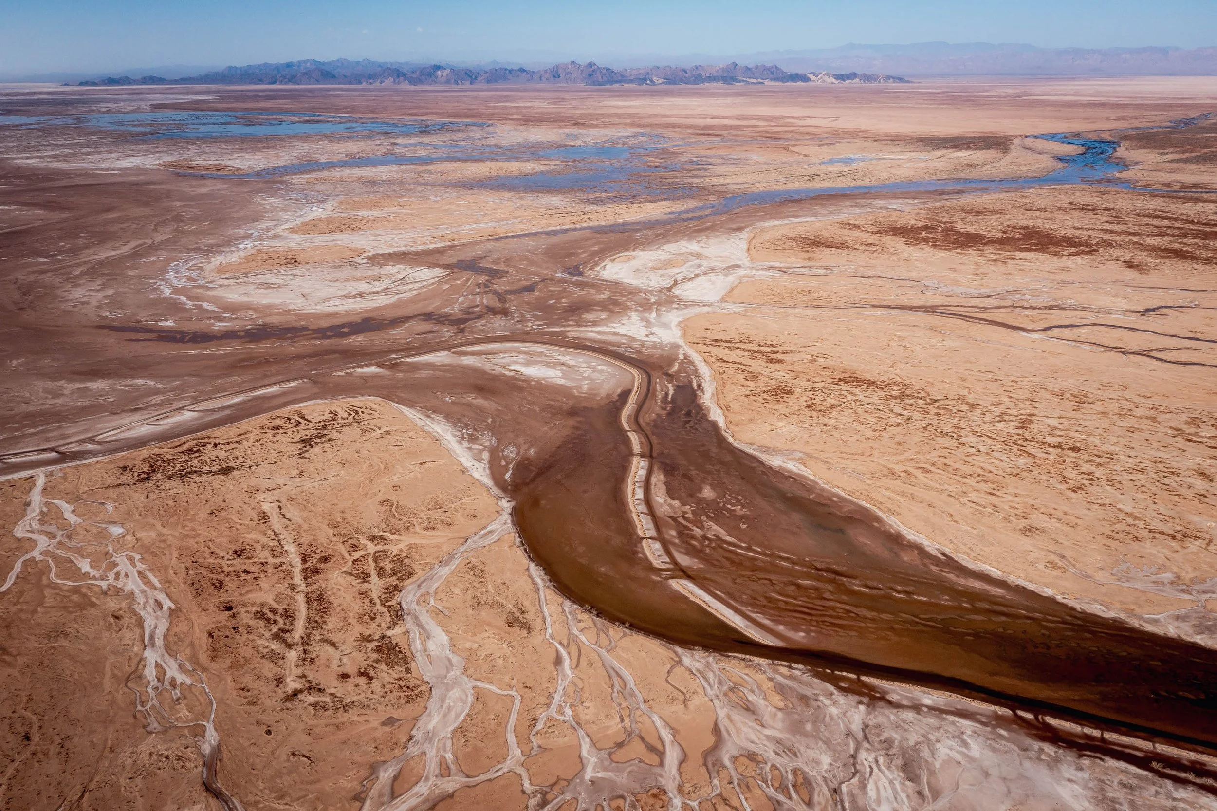
A small flow of water flows south in the Colorado River Delta in Baja California, Mexico on Thursday, June 23, 2022. Flows released into the delta under a binational agreement have allowed the river's water to reach this far, but it only reconnects with the sea when an especially high tide comes in to meet it in the estuary.
As if viewed through some perverse mirror, the Colorado River at its end bears some similarity to the river at its headwater. It’s a general rule of thumb that a river grows bigger as it flows downhill, picking up volume with every tributary.
But when the Colorado River reaches its terminus at the Gulf of California, it is scarcely bigger than the river at its start. However, instead of flowing through the lush high Rockies, the river fades away into a flat, seemingly dead expanse of dust.
Before the river was wrung dry to serve agriculture and growing cities, the delta was a verdant paradise inhabited by jaguars, beavers, deer and coyotes. Now, the river flows through a narrow channel surrounded by mud flats, meeting the sea only when the highest tide of the month pushes the saltwater high enough to flood the estuary and kiss the end of the river.
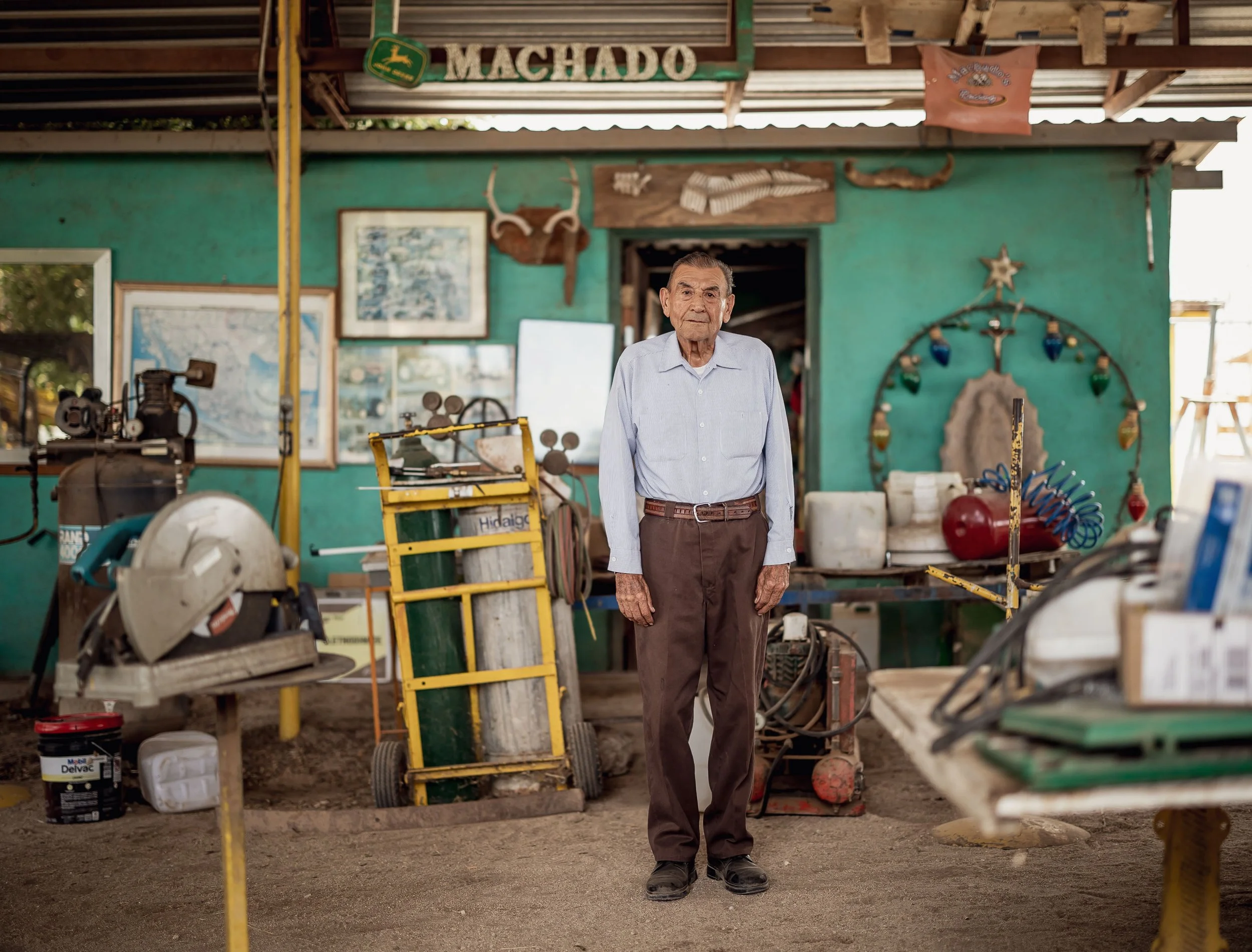
Manuel Machado Gerardo, 78, poses for a photo at his farm in Mexicali, Baja California, Mexico on Friday, June 24, 2022.
Manuel Machado Gerardo has lived and farmed in the Mexicali Valley for more than 50 years and has watched as the Colorado River diminished and the lush delta dried up.
“It’s sad. And it’s people who are responsible,” Gerardo said in Spanish. “Mostly the government, they’re responsible for the lack of conservation.”
When asked about the future of the Mexicali Valley and whether drought and the government’s policies will lead to its demise, Gerardo speaks with a cynical wisdom that comes from having a front-row seat to decades of climate change.
“I’ve seen the climate change, and the pollution of the seas. I might not (live to) see it, but it will be because of the lack of water. It’s a huge problem. And it will get worse,” he said.

A small flow of water moves through the Tijuana River, which has been converted into a paved channel, in Tijuana, Baja California, Mexico on Sunday, June 26, 2022.

Gustavo Rosales, 23, and his wife Adriana Mendoza, 22, stand outside their home in the Los Laureles neighborhood of Tijuana, Baja California, Mexico on Saturday, June 25, 2022.
Approximately 20% of the Mexico's allotted Colorado River water is piped up and over the Sierra de Juarez to reach Tijuana, home to 2 million people.
It’s not nearly enough. The city’s population has doubled since 2000 and many neighborhoods lack reliable access to water.
“We’re probably going to get the water cut soon. It could be any day,” said Adriana Mendoza, 22, standing outside her home in the Los Laureles neighborhood of Tijuana while her three children play nearby.
“Monthly, they cut the water for a whole week, or sometimes two weeks, in different neighborhoods. Every month,” Mendoza said.

Tomás Enrique Rivas Salcedo, a restoration specialist for the Sonoran Institute, walks through a restored forest near the banks of the Colorado River in Baja California, Mexico on Thursday, June 23, 2022.

Dry portions of the Colorado River Delta in the southern portion of the Mexicali Valley, Baja California, Mexico are pictured on Thursday, June 23, 2022.
Thanks to a binational agreement between the U.S. and Mexico, environmental groups trying to reverse this damage have a powerful tool at their disposal — water. A handful of miles upstream from the terminus, water gushes back out of the federal irrigation canals and into the river channel.
“When we started this, there was a lack of trust that this could even happen,” said Edgar Carrera, who has been working as a biologist in the delta for the last decade.
A coalition of non-governmental organizations including The Nature Conservancy and The Sonoran Institute have put that water to use replanting native flora and trying to restore stretches of the river to its former glory. With that, the ecosystem has made a stunning rebound.
The number of bird species recorded in the area jumped from 50 to 350, feeding on the fish that returned to the river. In restoration areas lining the river, thick stands of cottonwood trees shed their namesake seeds over the forest floor like feathers spilled from a down pillow. Beavers have come back, doing what beavers do best, resulting in lush ponds full of fish.
“We always take the water from the ecosystem, and this is the first time that we are working to put it back in,” said Carlos Restrepo, a monitoring specialist for the Sonoran Institute.
“We don’t want it, we want the river to have it.”

Edgar Carrera, the Colorado River Delta coordinator for The Nature Conservancy, swims after taking part in a community cleanup event at a popular swimming hole along the Colorado River in Mexicali, Baja California, Mexico on Friday, June 24, 2022.